ESRI Recommends GIS Technology for “Zika Virus” Control Geographical Information System Proves an Effective Tool Worldwide
Shocking Statistics!More Than 1 Million People Worldwide Die Every Year from Mosquito-Borne Diseases
The American Mosquito Control Association has revealed an alarming fact. Each year, over one million people in the world succumb to mosquito-borne diseases such as malaria, yellow fever, dengue, Chikungunya, West Nile and also Zika. The world, in particular, has now been closely watching Zika Virus after the World Health Organization (WHO) declared it a public health emergency on 1 February 2016. In Thailand, Zika infections have been detected in many provinces including Bangkok. Phetchabun, Chanthaburi, Beung Kan, and Chiang Mai are already listed as red-alert zones because Zika Virus has been spreading significantly in these provinces during the past three months.

Spatial Data & GIS Technology are Extremely Important to Disease Control
Dr. Este Geraghty, chief medical officer and health solutions director of ESRI, the United States, says, “Disease control must start with educating people about risks so that they can help with the prevention. People, for example, can provide information for risk reduction such as the eradication of Zika Virus vector Aedes aegypti mosquitoes. By integrating information from various sectors, relevant authorities will be able to better plan how to control or prevent the spread of Zika Virus. For timely responses, relevant authorities need spatial information, namely in rain-covered zones, hospital density, and the location of floodwater and standing water, mosquito breeding grounds, Zika patients and outbreak directions. Data can be digitally visualized in the form of an interactive map through GIS software. Such maps enable relevant authorities to easily see the “overall picture”, which supports smart situation assessments and decision-making in regards to the monitoring, control and public campaigns. Thanks to such maps, field staff can be efficiently dispatched to risky areas to easily prevent the spread of the disease in the most time-saving manner. On top of this, if the interactive map is made available to the public, people can also contribute to real-time reporting. Timely responses will thus be possible”.
GIS Technology Proves Effective in Battles against Zika Virus Around the World
With the help of GIS technology, several agencies around the world have efficiently monitored and controlled the Zika Virus.
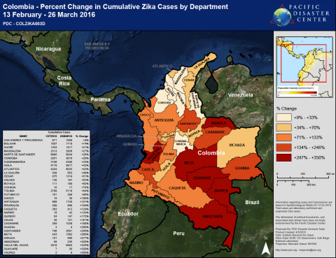
Special surveillance started in Florida, the United States, after more than 300 Zika infections were detected. Gathering and mapping such data—using GIS software from ESRI—is part of the US Department of Health & Human Services (HHS) Office of the Assistant Secretary for Preparedness and Response (ASPR) efforts to combat this growing health risk. Zika virus is very dangerous to pregnant women and developing fetuses. With GIS software, authorities can easily see areas with the highest number of pregnant women and assess the situation. ASPR also is using ESRI software to monitor the spread of the Zika virus across the United States and in 34 other countries where infections have been found. Through GIS, an interactive map is created showing the number of Zika cases in each state. Information is updated on a weekly basis and accessible to the public. Pacific Disaster Center (PDC), meanwhile, is using the ESRI platform to track the outbreak of the Zika virus on a global scale so as to share mapped intelligence with health services and aid responders in all regions around the world.
It’s not Just about Zika Virus! GIS Can Efficiently Tackle all Other Mosquito-Borne Diseases
Santa Cruz County Mosquito Abatement and Vector Control (MAVC) started using GIS technology in the late 1990s to identify potential mosquito breeding sites based on ground conditions and proximity to water. Locations of standing water were mapped, and the area calculated for proper larvicide application. To date, over 2,500 potential breeding sites have been mapped and are inspected on a biweekly or monthly basis. MAVC has also used mobile devices in gathering information on field. Data collection therefore is fast, convenient and accurate.
In Arizona, Maricopa County Environmental Services also leverages GIS technology to educate people about vector control. The informed public will have the knowledge to protect themselves from mosquito-borne diseases.
Today, Zika Virus is a global health threat with health agencies closely monitoring the spread of the disease. But it will take comprehensive “data” and clear map based on spatial data to enable effective surveillance and control. Only with proper location intelligence can disease-control teams make decisions faster and more efficiently. This explains why GIS technology is a crucial assistant for local, national and international agencies in their mission to efficiently protect people from infectious diseases.


